Plans
Wilmington Downtown Trail Phases 2 & 3
| Project: Wilmington Downtown Trail Phases 2 & 3 | Year: Ongoing - Anticipated by Summer 2024 |
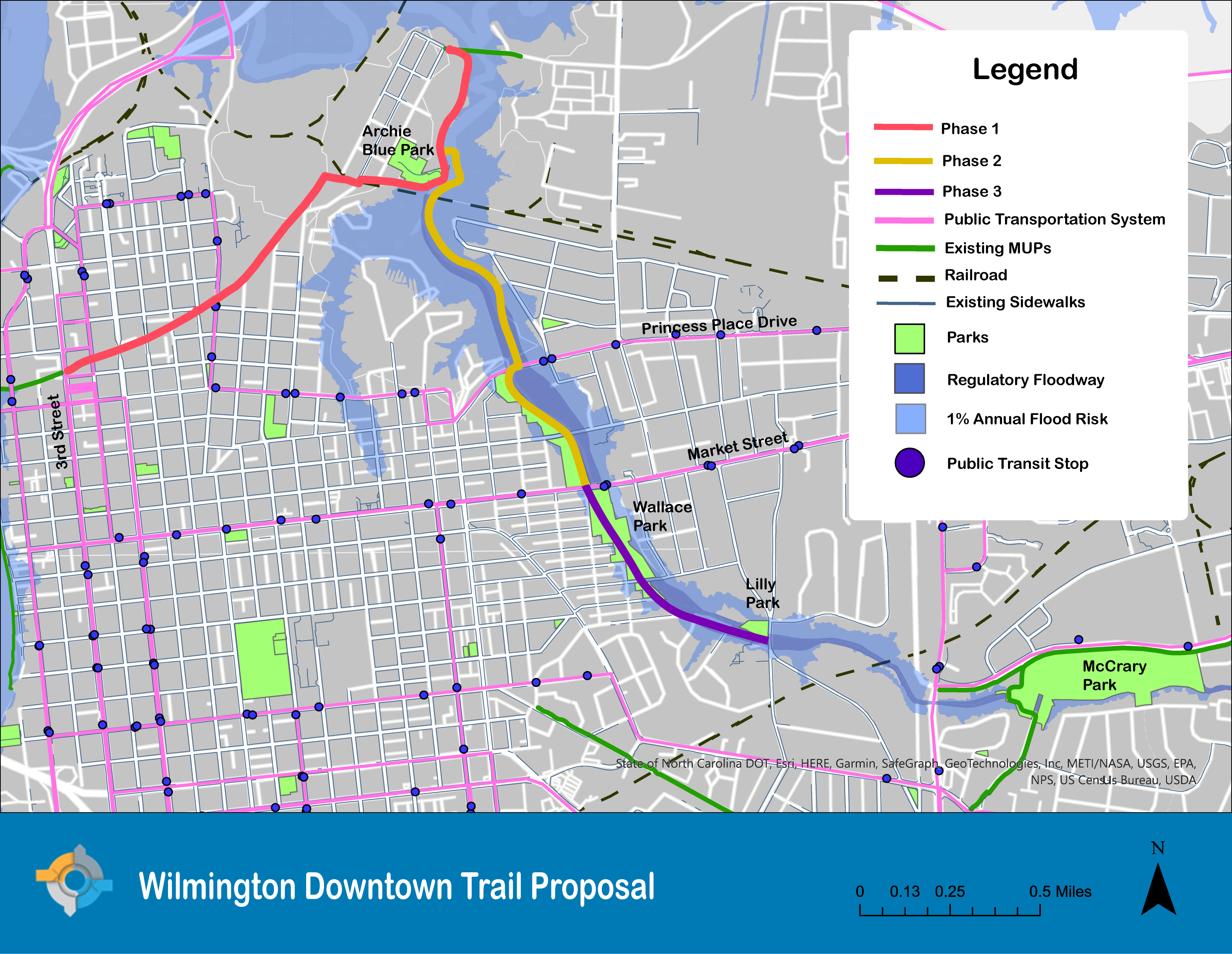
The purpose of this study would be to assess the feasibility of constructing a 10’-12’ multi-use path facility for Phases 2 and 3 of the Wilmington Downtown Trail. The Downtown Trail will eventually connect the River to Sea Bikeway to the future Multimodal Transportation Center, Cape Fear Community College, and the Riverwalk. In between these locations, the trail will provide a recreational facility for several communities in proximity to the downtown. The project currently consists of three phases. The first phase, from 3rd Street to Archie Blue Park, is in the preliminary engineering phase. |
|
| Project Files: Wilmington Downtown Trail Proposal |
|
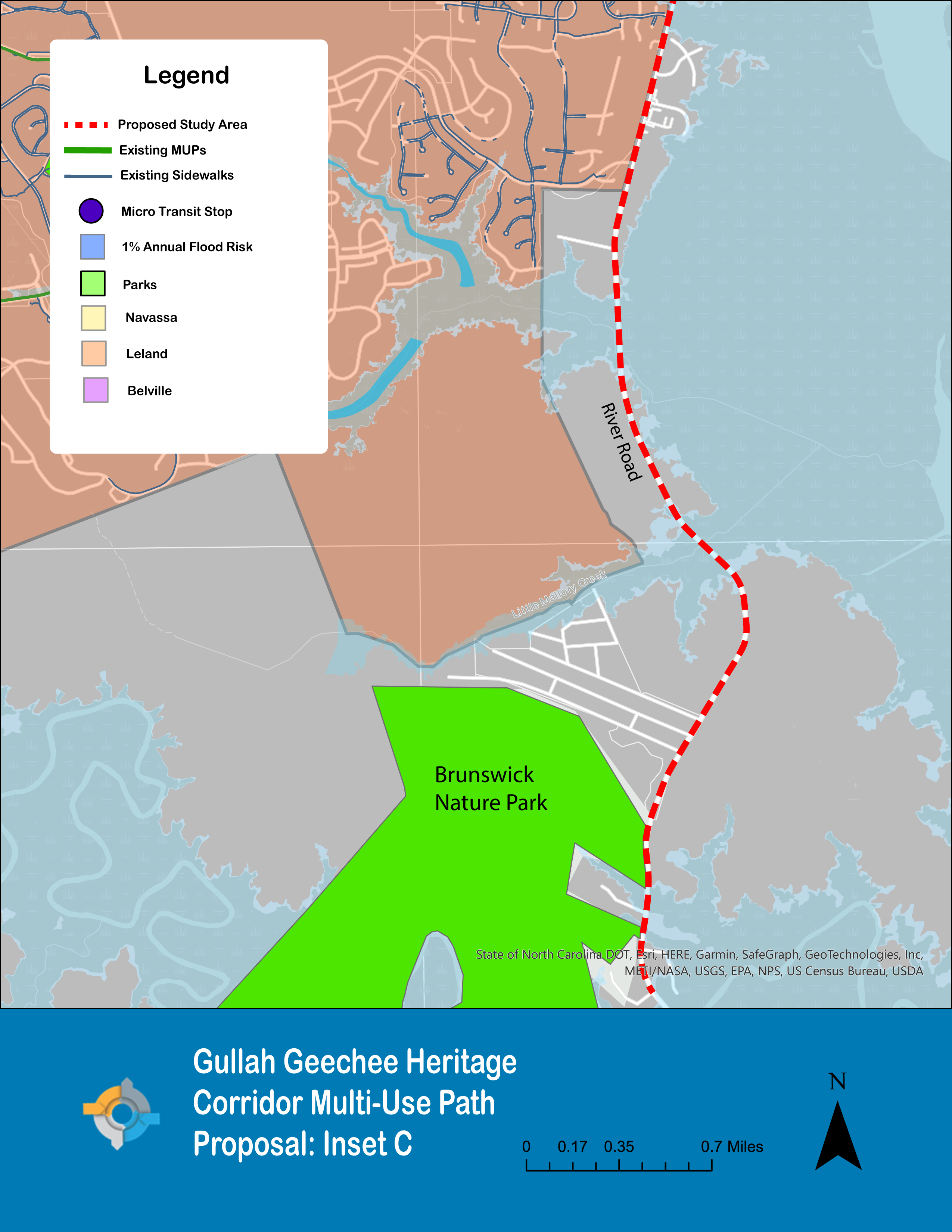
Gullah Geechee Heritage Corridor Greenway
| Project: Gullah Geechee Heritage Corridor Greenway | Year: Ongoing - Anticipated by Summer 2024 |
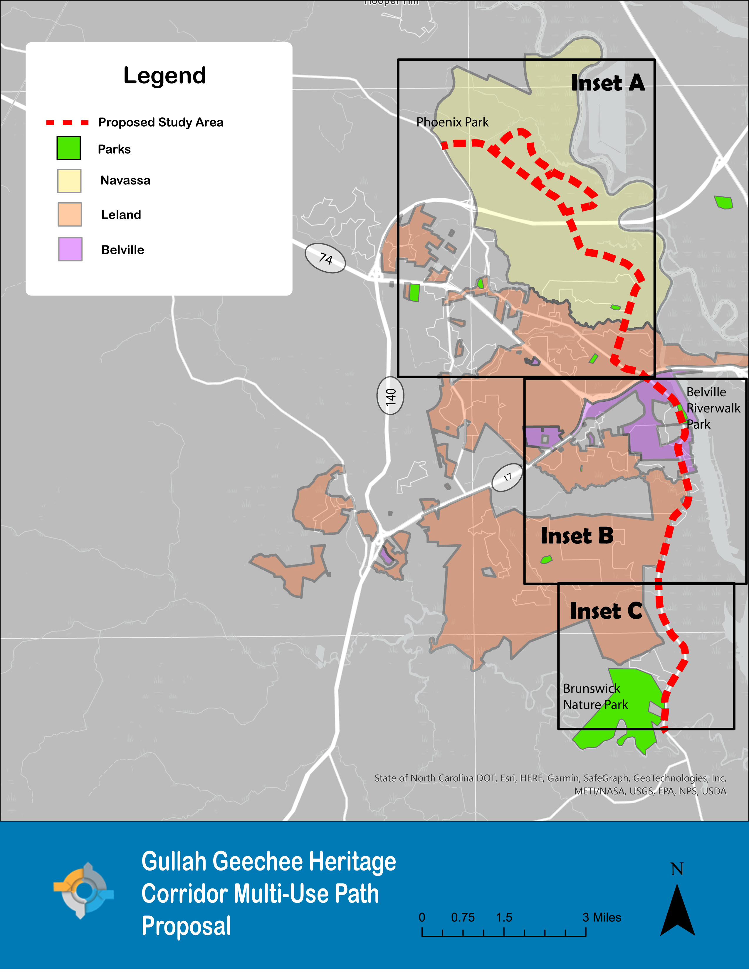
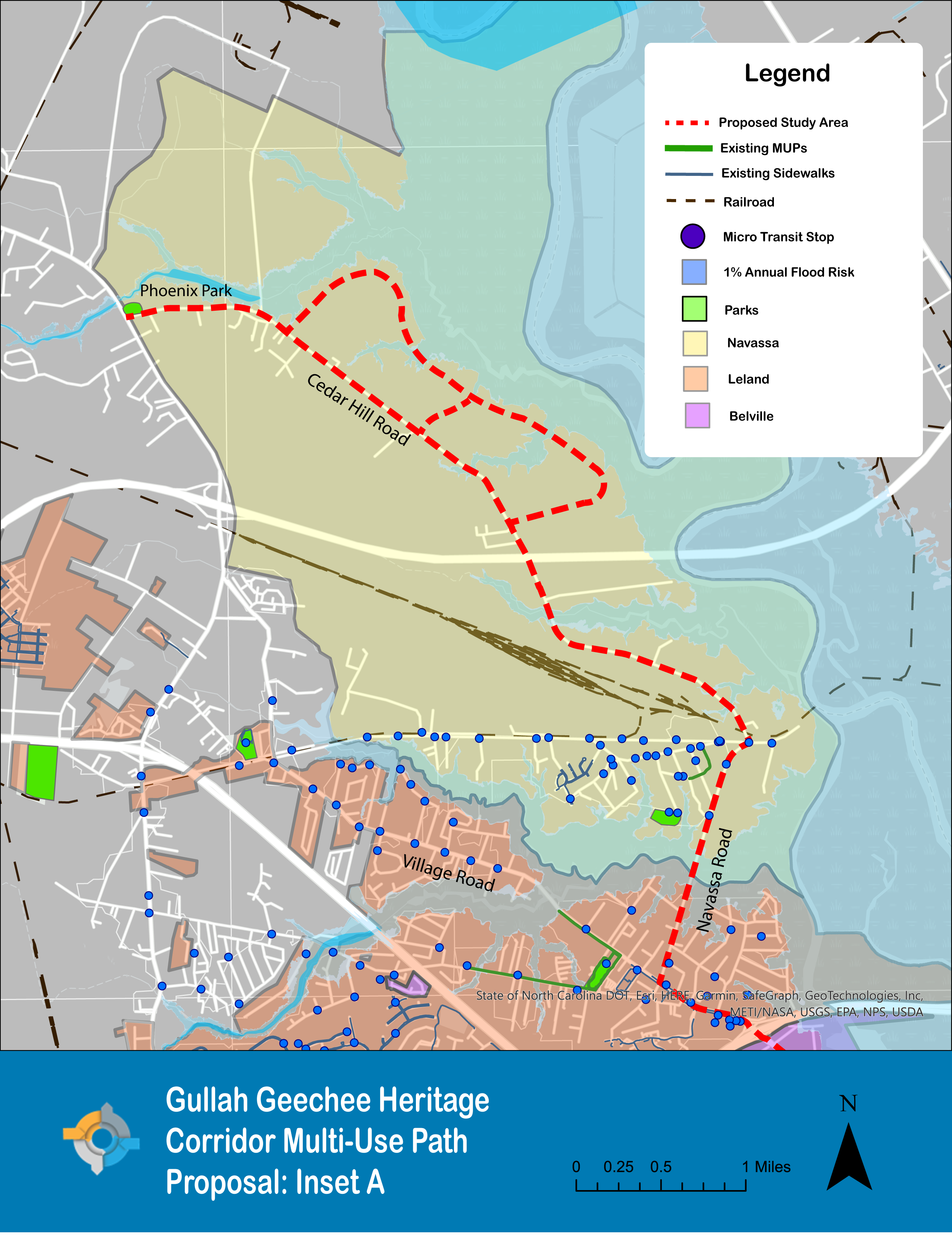
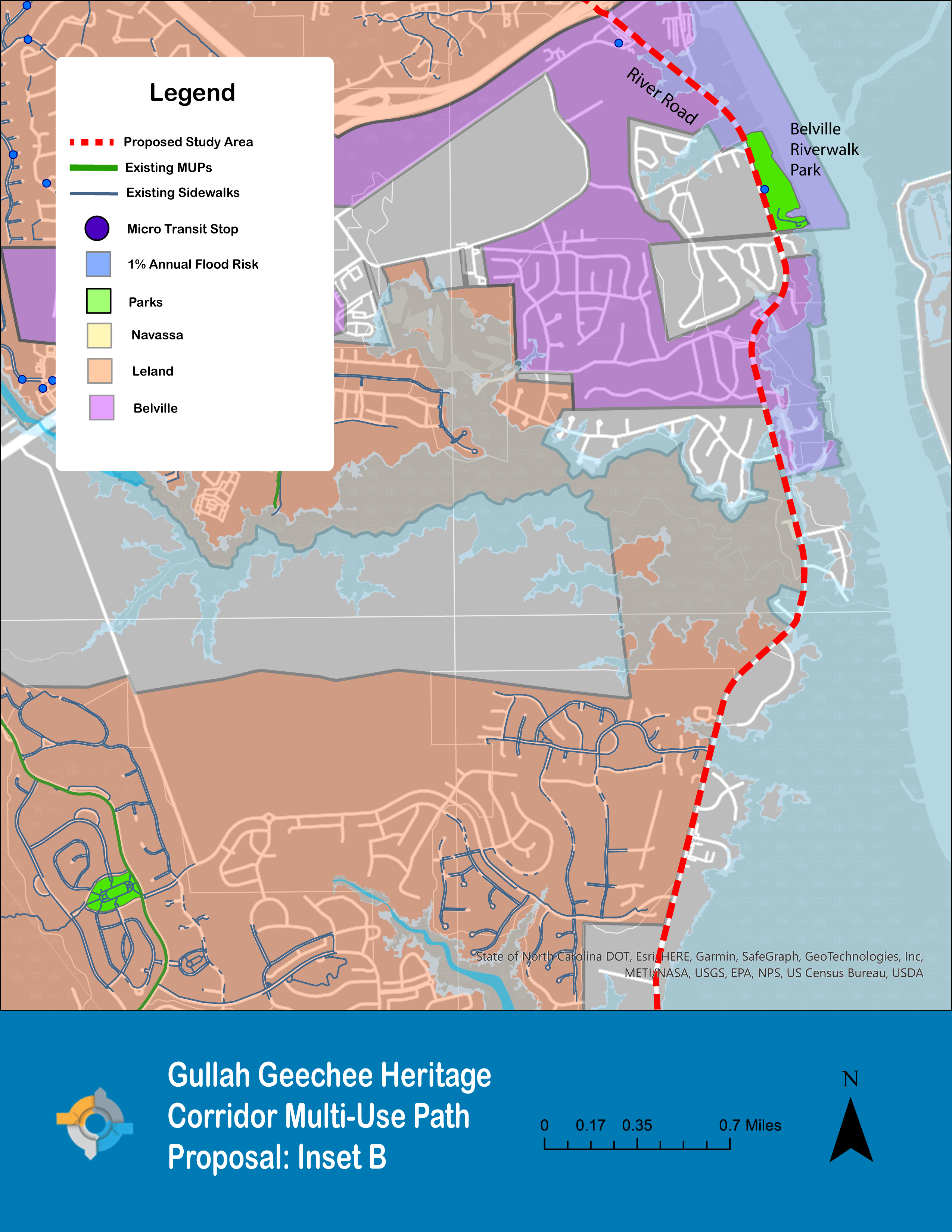
The purpose of this study would be to assess the feasibility of constructing a 10’-12’ multi-use path facility in the Gullah Geechee Heritage Corridor from Phoenix Park in Navassa to Brunswick Nature Park in unincorporated Brunswick County. The Gullah Geechee Heritage Corridor is designated as a Cultural Heritage Area by U.S. Congress, presenting an opportunity to educate the public about the history of the Gullah Geechee people and highlight historical sites within Brunswick County. To learn more about the project, click here. |
|
| Project Files: Gullah Geechee Trail Inset A, Navassa Inset B, Belville and Leland Inset C, Brunswick Nature Park |
|
Pender County Bicycle and Pedestrian Plan – DRAFT
| Project: Pender County Bicycle and Pedestrian Plan – DRAFT | Year: 2023 |
Pender County, in collaboration with the WMPO and consultant WSP, developed a comprehensive Bicycle and Pedestrian Plan to direct multimodal development within the southern portion of the County. The final plan will be used to prioritize bicycle and pedestrian infrastructure implementation that will improve mobility, increase safety, and strengthen the connectivity for multimodal transportation options in southern Pender County. |
|
| Project Files: Pender County Bicycle and Pedestrian Plan - Draft |
|
Walk Wilmington Pedestrian Plan Update
| Project: Walk Wilmington Pedestrian Plan Update | Year: 2023 |
The City of Wilmington, in recognizing the desire of its citizens for a more walkable, livable community, applied for and received an NCDOT Planning Grant in 2021 to update the 2009 Walk Wilmington Comprehensive Pedestrian Plan. Over 1,000 survey responses were received and used by Alta as a framework to guide the development of project and policy recommendations. The Walk Wilmington Steering Committee reviewed the draft priority areas identified through this framework. The updated plan will serve as a guide for prioritizing safe, healthy, and equitable pedestrian infrastructure improvements and policies in Wilmington. |
|
| Project Files: Walk Wilmington: Chapter 1 - Chapter 3 Walk Wilmington: Chapter 4 - Appendix B Walk Wilmington: Appendix C - Appendix D |
|
2022 Navassa Collector Street Plan
| Project: 2022 Navassa Collector Street Plan | Year: 2022 |
The 2022 Navassa Collector Street Plan will serve as a tool for the Town to guide both public and private investments in shaping the transportation network as the Town continues to grow. The plan recommends a comprehensive network of streets to safely and efficiently access major roads and thoroughfares, outlines collector street design standards, and identifies opportunities for multimodal connectivity, preparing the Town to serve future developments while preserving its existing neighborhoods. |
|
| Project Files: 2022 Navassa Collector Street Plan |
|
Town of Navassa Comprehensive Bicycle and Pedestrian Plan
| Project: Town of Navassa Comprehensive Bicycle and Pedestrian Plan | Year: 2022 |
The Town of Navassa Comprehensive Bicycle and Pedestrian Plan identifies and prioritizes projects, policies, and programs to improve the Town’s multimodal infrastructure. Plan development was guided by a steering committee and incorporated public input via an in-person public workshop as well as a project website and online comment map. |
|
| Project Files: Town of Navassa Comprehensive Bicycle and Pedestrian Plan |
|
Kure Beach Bicycle & Pedestrian Plan
| Project: Kure Beach Bicycle & Pedestrian Plan | Year: 2022 |
The Kure Beach Bicycle & Pedestrian Plan will aid the Town in the development and prioritization of its bicycle and pedestrian infrastructure needs. Plan development was guided by a steering committee and included two public meetings and stakeholder interviews as part of a 3-day charrette activity. Approximately 150 members of the public attended the public meetings, and an additional 436 responses were provided through an online interactive map tool. |
|
| Project Files: Kure Beach Bicycle & Pedestrian Plan |
|
DRAFT Locally Coordinated Public Transportation Plan
| Project: DRAFT Locally Coordinated Public Transportation Plan | Year: 2021 |
As required by the Federal Transit Authority (FTA), the Locally Coordinated Transportation Plan includes an assessment of available services by current public, private, and nonprofit transportation providers; an assessment of transportation needs for individuals with disabilities and seniors; strategies, activities, and/or projects to address the identified gaps between current and needed transportation services; identifies opportunities to achieve effectiveness in service delivery; and prioritizes implementation efforts based on available resources, feasibility, and time. |
|
| Project Files: Cape Fear Public Transportation Authority DRAFT Locally Coordinated Public Transportation Plan |
|
Wilmington Multi-Modal Center Phase 1B – Design Plans
| Project: Wilmington Multi-Modal Center Phase 1B – Design Plans | Year: 2021 |
These design plans are for the building renovation of 525 N 4th Street: a two-story brick building that will serve as the new office headquarters for the Wilmington Urban Area Metropolitan Planning Organization. The original brick structure was purpose built in 1894 for Thomas Grocery, a local retail establishment on the north side. The current design includes office space for current employees and a dedicated public room for WMPO Board meetings and official functions. The anticipated construction completion date is late 2023. |
|
| Project Files: WMPO Offices at 525 N 4th St |
|
Pender County Streets Plan 2021
| Project: Pender County Streets Plan 2021 | Year: 2021 |
This plan, which serves as an update to the 2016 Pender County Collector Street Plan, aims to improve connectivity, inform land development, maintain acceptable levels-of-service on existing roadways, ensure conservation of natural areas, and provide a safe and high-quality transportation network for residents, businesses, and visitors using all modes of travel in southeastern Pender County. The 2021 update, necessitated by high growth rates since 2016 as well as changes in regional plans and projects such as the adoption of the WMPO’s 2045 Metropolitan Transportation Plan (MTP), the NCDOT 2020-2029 State Transportation Improvement Program (STIP), a 2018 update to the County’s land use plan, and the progression of the US17/Hampstead Bypass, addresses future transportation needs while affording flexibility in implementation. |
|
| Project Files: Pender County Streets Plan 2021 |
|
Cape Fear Change in Motion 2020 Short-Range TDM Plan
| Project: Cape Fear Change in Motion 2020 Short-Range TDM Plan | Year: 2020 |
Cape Fear Change in Motion 2020 is the newest update to the Short-Range TDM Plan. The purpose of this plan is to recommend, support, and implement expansion of transportation options in the Wilmington Urban Area, and to essentially alter the perception of transportation from driving a personal vehicle to include the myriad of alternative transportation choices that are available in the region. The plan was adopted by the WMPO Board on April 28, 2021. |
|
| Project Files: Cape Fear Change in Motion 2020 Cape Fear Change in Motion 2020 Appendix |
|
Cape Fear Memorial Bridge Replacement Feasibility Study
| Project: Cape Fear Memorial Bridge Replacement Feasibility Study | Year: 2020 |
The study considers alignment and height alternatives for the replacement of the existing 4-lane steel, center-span, vertical-lift bridge. The proposed bridge replacement would consist of a 6‐lane median‐divided facility with a barrier‐separated multi‐use path. The project is needed to accommodate local population increases and truck traffic for the Port of Wilmington. A new bridge will improve traffic flow, and provide bicycle/pedestrian connectivity across the river. |
|
| Project Files: Study Alternative Maps Express Design Summary Project Initiation Form Scoping Checklist |
|
Wilmington Rail Trail Master Plan
| Project: Wilmington Rail Trail Master Plan | Year: 2020 |
In January 2020, the Wilmington MPO and the Friends of the Wilmington Rail Trail kicked off the development of a multimodal master plan for the downtown rail corridor between 3rd Street and McRae Street. The effort was funded by the WMPO’s federal Direct Attributable program and a donation from the Arts Council of Wilmington and New Hanover County. The purpose of the plan is to address the feasibility for use of the corridor by bicycles, pedestrians, and future passenger rail service. The final plan offers potential alignment and points of access, as well as recommendations for the integration of public art into the corridor. The development of the plan was guided by a steering committee comprised of WMPO, City of Wilmington, and NCDOT staff, as well as members of the Friends of the Wilmington Rail Trail, the Arts Council, and citizen advocates for the project. Stakeholder involvement and the understanding of existing conditions and constraints was incorporated into the plan’s development as well as public input attained through a public survey and 14-day public comment period on the draft plan. The final plan, which can be viewed at the link below, was adopted by the WMPO Board on November 18, 2020. |
|
| Project Files: Wilmington Rail Trail Master Plan |
|
Carolina Beach Pedestrian Plan
| Project: Carolina Beach Pedestrian Plan | Year: 2019 |
This Plan is intended to provide a framework for identifying pedestrian needs, both in terms of physical infrastructure and encouragement programs for the Town of Carolina Beach. The vision for this pedestrian master plan is to enhance the livability of Carolina Beach by creating an appealing, walkable environment for both residents and visitors. |
|
| Project Files: Carolina Beach Pedestrian Plan |
|
Wilmington Traffic Separation Study
| Project: Wilmington Traffic Separation Study | Year: 2017 |
In a joint effort with the City of Wilmington, CSX, and the Wilmington MPO, NCDOT has completed the Wilmington Traffic Separation Study (TSS), focusing on 26 existing at-grade roadway-railroad crossings along a 6-mile span of the CSXT rail line. NCDOT uses a TSS to systematically review crossing safety. Traffic Separation Studies comprehensively evaluate traffic patterns and road usage for an entire municipality or region, determining the need for improving and/or eliminating public grade crossings. |
|
| Project Files: Wilmington Traffic Separation Study |
|
Wilmington Rail Relocation Feasibility Study
| Project: Wilmington Rail Relocation Feasibility Study | Year: 2017 |
The City of Wilmington, the Wilmington Urban Area Metropolitan Planning Organization, and the NC Department of Transportation directed that a study be performed to investigate the feasibility of realigning the existing CSXT railroad line that traverses in a “V” shape through the City. Moving this line will provide a new location for rail access to the Port, and offer the potential of repurposing the existing CSXT railroad corridor for transit use. |
|
| Project Files: Wilmington Rail Relocation Feasibility Study |
|
US 17 Business (Market St) Corridor Study
| Project: US 17 Business (Market St) Corridor Study | Year: 2016/2007 |
This study evaluates alternative cross-sections for the US 17 Business (Market Street) corridor from Covil Avenue to 3rd Street in the City of Wilmington. In 2016 a study was completed to re-evaluate affected intersections to guide the decision-making process toward action. |
|
| Project Files: US 17 Business (Market St) Corridor Study Update (2016) US 17 Business (Market St) Corridor Study (2007) |
|
Comprehensive Transportation Plan (CTP)
| Project: Comprehensive Transportation Plan (CTP) | Year: 2016 |
The Comprehensive Transportation Plan (CTP) is North Carolina’s multi-modal transportation plan. The CTP represents a community’s consensus on the future transportation system (including the existing system and improvements) needed to support anticipated growth and development over a 25-30 year timeframe. When a CTP is adopted by NCDOT, it represents the state’s concurrence with the identified transportation needs and proposed recommendations. |
|
| Project Files: CTP |
|
Leland Pedestrian Plan
| Project: Leland Pedestrian Plan | Year: 2016 |
This is the first pedestrian plan for the Town of Leland. The plan will be used to identify and prioritize pedestrian and greenway projects in Leland. It will also help enhance the pedestrian environment by guiding community programs, getting projects into the state STIP, improving eligibility for other funding, and connecting a pedestrian network. |
|
| Project Files: Leland Ped Plan |
|
Town of Wrightsville Beach Community Transportation Plan
| Project: Town of Wrightsville Beach Community Transportation Plan | Year: 2013 |
This plan examines and addresses comprehensive transportation issues in the Town of Wrightsville Beach to include traffic congestion, safety, pedestrian and bicycle circulation, and parking issues. |
|
| Project Files: Town of Wrightsville Beach Community Transportation Plan |
|
Connecting Northern Brunswick County Collector Street Plan
| Project: Connecting Northern Brunswick County Collector Street Plan | Year: 2013 |
This plan aims to increase connectivity in northern Brunswick County through improving the collector street network for the Towns of Leland and Navassa. |
|
| Project Files: Connecting Northern Brunswick County Collector Street Plan |
|
Wilmington-New Hanover County Comprehensive Greenway Plan
| Project: Wilmington-New Hanover County Comprehensive Greenway Plan | Year: 2013 |
This plan provides a framework for the establishment of a comprehensive network of greenways in the City of Wilmington and New Hanover County to enhance opportunities for multi-modal transportation and recreation to include plans for walking, bicycling, canoeing and kayaking. |
|
| Project Files: Plan Maps Final Draft Appendix |
|
River to Sea Bikeway Master Plan
| Project: River to Sea Bikeway Master Plan | Year: 2013 |
This is an 11-mile on-and-off-road bicycle route that follows the Historic Beach Car Line.The bikeway is comprised of neighborhood residential streets, off-road multi-use paths and a few arterial roadways. It provides bicycle and pedestrian access to numerous recreational, cultural, and educational destinations in Wilmington and Wrightsville Beach. |
|
| Project Files: River To Sea Bikeway Master Plan |
|
US 17/ NC 210 Corridor Study
| Project: US 17/ NC 210 Corridor Study | Year: 2012 |
This study was commissioned to identify near-term strategies to address safety and mobility deficiencies on US 17 and NC 210 in Hampstead. The plan provides recommendations that include access management strategies, design elements, traffic enforcement, and collector street recommendations. |
|
| Project Files: US 17/ NC 210 Corridor Study |
|
Cross-City Trail Master Plan
| Project: Cross-City Trail Master Plan | Year: 2012 |
In 2008, the Wilmington City Council adopted the Cross-City Trail alignment. Tentative plans for the Cross-City Trail arose from the passage of the Parks and Greenspace Bond, of which $1 million was allocated for a bike-hike greenway system, and expanded through private and public partnerships and through connections to existing or funded off-road trails. The trail is anticipated to be fully constructed by the end of 2016.
|
|
| Project Files: Cross-City Trail Master Plan |
|
Market Street Corridor Study
| Project: Market Street Corridor Study | Year: 2011 |
This corridor plan integrates transportation and land use planning in an effort to improve safety and mobility along the Market Street corridor from Colonial Drive to the Pender County line. The plan provides recommendations for access management, inter-connectivity, improved development standards, future collector streets and conceptual designs. |
|
| Project Files: Market Street Corridor Study |
|
Eastwood Road Preferred Access Map
| Project: Eastwood Road Preferred Access Map | Year: 2011 |
This preferred access plan illustrated preferred access management initiatives for the Eastwood Road corridor. |
|
| Project Files: Eastwood Road Preferred Access Map |
|
Carolina Beach Bicycle Multi-Use Transportation Plan
| Project: Carolina Beach Bicycle Multi-Use Transportation Plan | Year: 2011 |
This plan creates a vision and framework for Carolina Beach to become a more bicycle and multi‐use path friendly environment that provides inter-connectivity to the various town destinations. |
|
| Project Files: Carolina Beach Bicycle Multi-Use Plan |
|
Transit Needs Study for the Wilmington Multi-Modal Transportation Center
| Project: Transit Needs Study for the Wilmington Multi-Modal Transportation Center | Year: 2009 |
This study represents the latest stage in the development of the Wilmington Multi-Modal Transportation Center, including the site’s functional layout and specific land requirements. |
|
| Project Files: Transit Needs Study for the Wilmington Multi-Modal Transportation Center |
|
Corridor Study Dow Road Carolina Beach, NC
| Project: Corridor Study Dow Road Carolina Beach, NC | Year: 2009 |
This study evaluates alternative scenarios for Dow Road from its northern terminus at US 421 (Lake Park Boulevard) to K Avenue in Kure Beach and the feasibility and impacts of extending Dow Road from K Avenue south to Fort Fisher. |
|
| Project Files: Corridor Study Dow Road Carolina Beach, NC |
|
Walk Wilmington: A Comprehensive Pedestrian Plan 2009
| Project: Walk Wilmington: A Comprehensive Pedestrian Plan 2009 | Year: 2009 |
In 2007, the City of Wilmington received a grant from the North Carolina Department of Transportation to develop a comprehensive pedestrian plan. The final plan was adopted by Wilmington City Council on August 4, 2009. With this plan, the City of Wilmington and NCDOT hope to meet the demands for safer and more extensive pedestrian facilities, including greenways, sidewalks, and crosswalks. The comprehensive pedestrian plan will guide local, regional and state efforts to improve conditions for walking in the City of Wilmington and increase our reputation as one of the premier tourism and recreation destinations in the southeast. |
|
| Project Files: Executive Summary Full Plan Appendices |
|
Pelican Drive/Salisbury Street Bicycle Plan for the Town of Wrightsville Beach
| Project: Pelican Drive/Salisbury Street Bicycle Plan for the Town of Wrightsville Beach | Year: 2009 |
This study examines different alternatives for on-road and off-road bicycle facilities along the Pelican Drive and Salisbury Street corridor in the Town of Wrightsville Beach. |
|
| Project Files: Plan Recommended Designs |
|
Cape Fear Historic Byway Corridor Management Plan
| Project: Cape Fear Historic Byway Corridor Management Plan | Year: 2008 |
This plan strives to preserve the historical integrity, reveal the natural character, convey the social diversity, celebrate the varied attractions, and enhance the many modes of transportation of Cape Fear Historic Byway, the first entirely urban scenic byway in the state of North Carolina. |
|
| Project Files: Cape Fear Historic Byway Corridor Management Plan |
|
Comprehensive Bicycle Plan for Leland
| Project: Comprehensive Bicycle Plan for Leland | Year: 2008 |
The Comprehensive Bicycle Plan for Leland was adopted in 2008. This Plan provides the Town with a planning tool, which will assist in the expansion, promotion, and funding of safe and efficient bicycle facilities and programs and initiatives throughout Leland. |
|
| Project Files: Leland Bike Plan Final |
|
River Road Small Area Plan
| Project: River Road Small Area Plan | Year: 2007 |
This plan was developed to identify the future transportation improvements required for the fast-growing area of southern New Hanover County bounded by Independence Boulevard, Carolina Beach Road, Sanders Road and the Cape Fear River. |
|
| Project Files: River Road Plan |
|
Dawson & Wooster Corridor Plan
| Project: Dawson & Wooster Corridor Plan | Year: 2007 |
This plan evaluates measures to improve safety in the short-term for the Dawson Street and Wooster Street study area in the City of Wilmington, particularly South 6th Street at Wooster Street, and identifies opportunities and constraints in an effort to define a long-range future vision for the roadway couplet. |
|
| Project Files: Dawson & Wooster Corridor Plan |
|
US 17/NC 133 Collector Street Plan
| Project: US 17/NC 133 Collector Street Plan | Year: 2007 |
The purpose of this plan is to inventory the existing collector street network and develop standards and policies that will promote future connectivity and accommodations for automobiles, transit, pedestrians, and bicycles as collector streets are constructed within the area bounded by US Highway 17, NC 133 and Town Creek in Brunswick County. |
|
| Project Files: US 17/NC 133 Collector Street Plan |
|
Wilmington Multi-Modal Transportation Center Site Evaluation Report
| Project: Wilmington Multi-Modal Transportation Center Site Evaluation Report | Year: 2005 |
This study examines potential sites for a multi-modal transportation center in the Wilmington region. This center would potantially support intracity buses, intercity buses, passenger rail, taxi services and other transportation modes. |
|
| Project Files: Wilmington Multi-Modal Transportation Center Site Evaluation Report |
|
Wilmington Multi-Modal Transportation Center Feasibility Study
| Project: Wilmington Multi-Modal Transportation Center Feasibility Study | Year: 2000 |
This study identifies the need for a multi-modal transportation center in the Wilmington Urban Area. The study further identifies the best area for the facility and assesses the feasibility of construction. |
|
| Project Files: Wilmington Multi-Modal Transportation Center Feasibility Study |
|